

In years past we would have gone for a drive out to the "outer beach" to where the Outermost House, of Henry Beston fame once stood. The literary landmark was washed out to sea during storm of 1978. The outer beach was a spit of land that stretched half a mile or farther beyond the Coast Guard Station and was maybe 500 yards wide. There were several summer cottages out there nestled in the dunes. It was a great area for private cook outs on the beach, since you had to have a beach vehicle to get there. Now the area is closed due to the spotted plover living out there and they are an endangered species... well I didn't look it up, if not endangered they are protected anyway. Coast Guard Beach looking south
 Thumpertown Beach, Cape Cod Bay, Eastham, MA
These two pictures are from the bayside at low tide. The bay was a neat place to take young kids as you can see the little pools and sandbars. I remember razor clams that cut your feet and crabs that bit your toes... I preferred the ocean. Not sure if it was my adventuresome spirit... or that it was just what I was used to. We sort of had an attitude that the bayside beaches were for sissies. Ansel was intrigued by how far the water was, and that the boats were sitting on their sides. I wanted to go back and get a picture of the moored boats at high tide so he could see the difference, but ran out of time. The moored boat belongs to a beach house to the right of the picture. It lives there for the summer, and when they want to use it, they take a dingy out when the tide is up and switch the boats, leaving the dingy on the mooring while they use the boat.
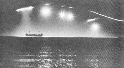
Summer thunder and lightening storms over the bay were always pretty entertaining. It was odd looking at the bay and not seeing the Target Ship on the horizon. There used to be a decommissioned Navy ship out in the middle of the bay. It was grounded there on purpose for military training exercises. Growing up, we called it the Target Ship, as it was used for target practice by the Air Force. If you go to the Cape Cod map in an earlier post, there is a gray area on the west end of the Cape, and that was Otis Air Force Base. Now I think it is Air National Guard. Anyway going to bay at night was another special night time thing to go to the bay for was to watch them practice after dark. Not sure the chemical make up of what they dropped from the bombers on the Target Ship, but they would flare and light up as they dropped and you could hear the boom. Over the years... 60 I assume, with the combination of the salt water and weather it has deteriorated into oblivion and is no more.
I just googled it... the "Target Ship in Cape Cod Bay, was originally the USS James Longstreet, a war time emergency cargo freighter. In 1943 it ran aground off New Jersey and was declared a total loss, so the Navy took possession of it and in 1944 placed it in Cape Cod Bay for guided missle bombing practice. Here are some pictures of how I remembered it from my childhood. 


 Then we took a drive to
  MacMillan Wharf, Provincetown Hah-ba :0)
 This is the