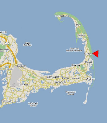
Eastham, where Nauset Light and Coast Guard Beach are. The town of Eastham is apprx. 3 miles wide.
Cape Cod, known as "The Cape" is shaped like an arm. The bicep part of the arm closest to the mainland is called the 'upper cape' and the fore arm, wrist and fist - farthest from the mainland is referred to as the 'lower cape'. The town of Chatham would be the elbow. This is all admittedly a little oxy-moronish since much of the 'lower cape' is actually north of the 'upper cape'. Cape Cod was shaped by glaciers on all sides and it’s really just a large sand bar. Cape Cod was discovered by Gosnold Champlain in 1607, the pilgrims arrived and looked it over in 1920, first mooring the Mayflower in Cape Cod Bay, and sending a scouting boat to explore the Cape lands on the bayside. When they landed at Eastham, they had their First Encounter with the Wampanoag Indians... the bayside beach is thus named First Encounter Beach with a small monument documenting the event. The Pilgrims ended up sailing west across the bay to land near Plimouth, MA.
'Upper' Cape towns include Bourne, Falmouth, Mashpee, and Sandwich. 'Mid' Cape towns include Barnstable, Brewster, Dennis, Harwich, and Yarmouth. 'Lower' Cape towns include Chatham, Eastham, Orleans, Provincetown, Truro, and Wellfleet. For those curious, the Kennedy Compound is at Hyannisport (not shown) just west of Yarmouth.


